“Water is the driving force of all nature.” – Leonardo da Vinci

Water Plant Transmission Mains
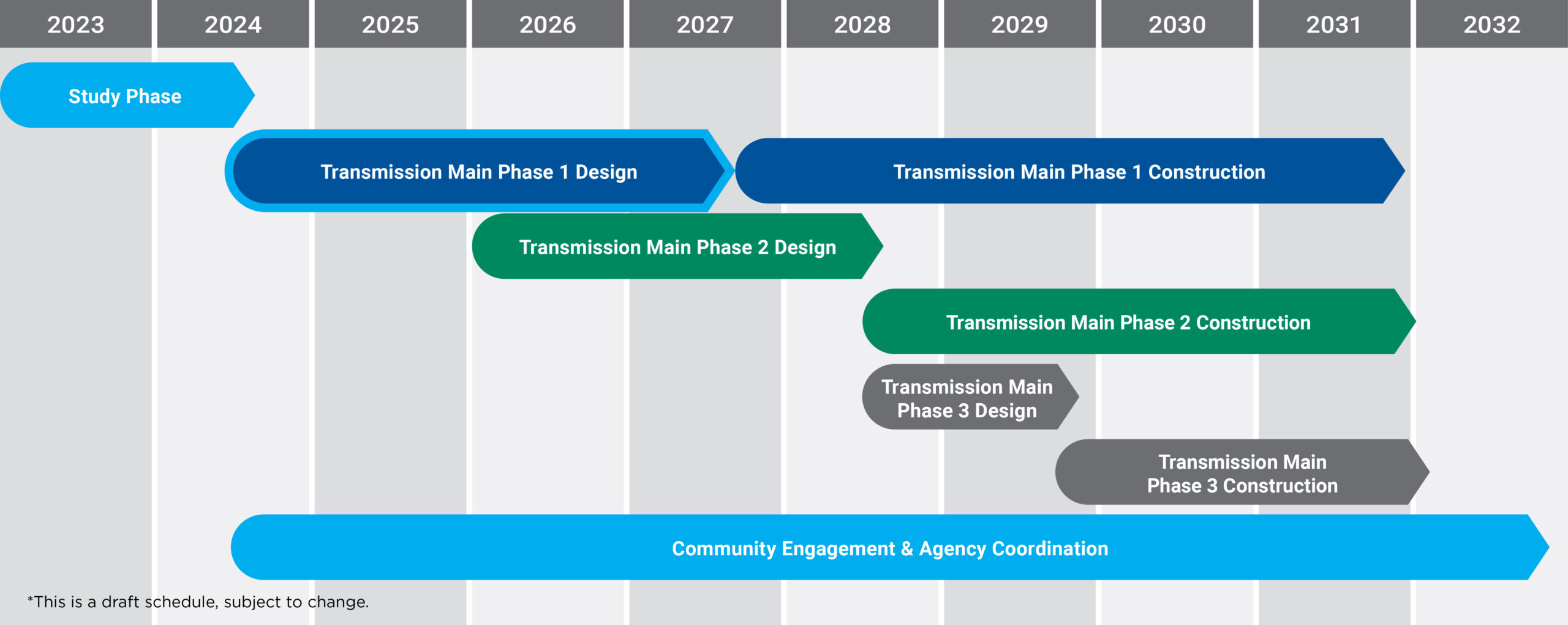
Project Overview
To meet the growing need for clean, safe drinking water in central Ohio, the City of Columbus is building a fourth water plant along the Scioto River near the corner of Home and Dublin roads in Delaware County. Water transmission mains – two large pipes approximately 48 inches in diameter – will be built to directly connect the new Home Road Water Plant to the Columbus Water & Power water distribution system near the Blazer Parkway area and other strategic areas in northwest Columbus.
Columbus Water & Power currently provides an average of 149 million gallons per day (MGD) to residents of Columbus and more than two dozen other central Ohio communities. These needed improvements will provide additional water treatment capacity, increased reliability, and relief for the three existing Columbus water plants. The new plant will also provide additional capacity needed to address expected regional growth and demand.
The first engineering phase of the transmission mains project involved evaluating multiple corridors and narrowing them down to the most viable routes. The second engineering phase, currently underway, aims to identify the most feasible alignments based on ease of access for transmission main maintenance, business and residential impacts, availability of easements, environmental considerations, traffic and active transportation impacts, utility conflicts, overall costs, and other identified risks.
Announcements
AEP Neighborhood Meeting – June 2026
Check out the meeting presentation.
Ashbaugh Neighborhood Meeting – June 2026
Check out the meeting presentation and exhibits.
Updated FAQs
Check out our updated FAQs.
Learn the latest about the new Home Road Water Plant and Water Plant Transmission Mains projects. The public meeting presentation is available to review from the December 3, 2024 public meeting.
FIELD INVESTIGATIONS
Before the final transmission main alignments can be confirmed, survey crews need to conduct a series of investigations and field surveys. These investigations are occurring within road right-of-way areas and on some private property and continue through design of the project.
The City of Columbus is notifying impacted property owners and occupants by mailing notification letters. The City of Dublin is notifying residents about these activities on Nextdoor and other communication channels, and Concord Township is posting information on its website.
Sample notifications are shown below.
Weekly Field Activities
FIELD SURVEY & INVESTIGATIONS
Field Investigation | Begins Monday, August 3 | Between 7:00 a.m. and 7:00 p.m. | Survey Teams: ms consultants and Columbus Water & Power
Field crews will need to enter and survey the rear of private properties along the Ashbaugh corridor. Crews will examine updated landscaping, cleared honeysuckle, and removed or planted trees since the area was originally surveyed. No digging or equipment will be necessary. We do not need to enter any buildings on your property.
5608 FAWNBROOK LN DUBLIN, OH 43017
5616 FAWNBROOK LN DUBLIN, OH 43017
5624 FAWNBROOK LN DUBLIN, OH 43017
5632 FAWNBROOK LN DUBLIN, OH 43017
5640 FAWNBROOK LN DUBLIN, OH 43017
5644 FAWNBROOK LN DUBLIN, OH 43017
5648 FAWNBROOK LN DUBLIN, OH 43017
5652 FAWNBROOK LN DUBLIN, OH 43017
5656 FAWNBROOK LN DUBLIN, OH 43017
5660 FAWNBROOK LN DUBLIN, OH 43017
5702 LYNX LN DUBLIN, OH 43017
5707 LYNX LN DUBLIN, OH 43017
5710 LYNX LN DUBLIN, OH 43017
5715 LYNX LN DUBLIN, OH 43017
5720 BRAND RD DUBLIN, OH 43017
5750 MEMORIAL DR DUBLIN, OH 43017
8002 LUCKSTONE DR DUBLIN, OH 43017
8010 LUCKSTONE DR DUBLIN, OH 43017
8018 LUCKSTONE DR DUBLIN, OH 43017
8026 LUCKSTONE DR DUBLIN, OH 43017
8034 LUCKSTONE DR DUBLIN, OH 43017
8042 LUCKSTONE DR DUBLIN, OH 43017
8050 LUCKSTONE DR DUBLIN, OH 43017
8058 LUCKSTONE DR DUBLIN, OH 43017
8066 LUCKSTONE DR DUBLIN, OH 43017
8074 LUCKSTONE DR DUBLIN, OH 43017
8082 LUCKSTONE DR DUBLIN, OH 43017
____________________
Subsurface Utility Engineering (SUE) Field Investigation | Begins Monday, June 22 | Between 7:00 a.m. and 7:00 p.m. | Survey Teams: DHDC Engineering Consulting Services, LJB Underground Services, Resource International, Gresham Smith, ms consultants and Columbus Water & Power
Field crews will conduct subsurface field investigations along Concord Road, from Glick Road north to the Dublin city limits. Traffic impacts are not expected. Thru traffic and property access on Concord Road will remain open, and no roadways will be closed.
6045 ST BOSWELS CT
6073 ST BOSWELS CT
9010 BARASSIE PL
8969 SUNNINGDALE LN
9030 BARASSIE PL
8372 MUIRFIELD DRIVE
8977 SUNNINGDALE LN
8985 SUNNINGDALE LN
9020 BARASSIE PL
6097 DEESIDE DR
6059 ST BOSWELS CT
____________________
Subsurface Utility Engineering (SUE) Field Investigation | Begins Monday, June 22 | Between 7:00 a.m. and 7:00 p.m. | Survey Teams: DHDC Engineering Consulting Services (DHDC), Resource International, Gresham Smith and ms consultants
Field crews will conduct subsurface field investigations along Concord Road, from Glick Road to just south of the Harriott Road roundabout, within Concord Township. Traffic impacts are not expected. Thru traffic and property access on Concord Road will remain open, and no roadways will be closed.
____________________
Field Surveys | Begins Monday, July 20 | Between 8:00 a.m. and 5:00 p.m. | Survey Teams: Gresham Smith and ms consultants
Field crews will conduct field walks to obtain data on the existing conditions across your property. This includes collecting information on existing fences, trees, and paths, as well as taking photographs. More than one entry may be required. The Water Plant Transmission Mains project team is also coordinating this effort with AEP officials.
7178 HARRIOTT RD
7220 HARRIOTT RD
6970 HARRIOTT RD
6959 CONCORD BEND DR
6935 CONCORD BEND DR
6685 COOK RD
6631 COOK RD
6503 COOK RD
6558 COOK RD
6498 COOK RD
6494 COOK RD
6420 COOK RD
6398 COOK RD
6300 COOK RD
6386 COOK RD
6404 COOK RD
6468 COOK RD
6278 COOK RD
8656 DUBLIN RD
6580 COOK RD
6385 HOME RD
6490 COOK RD
____________________
WATER WELL COLLECTION | Friday, July 24th | 7:00 a.m. and 7:00 p.m. | Survey Team: Eagon & Associates
We will be collecting water levels at previously installed monitoring wells along all WPTM alignments. All testing will occur within the public right-of-way of the City of Dublin and Concord Township.
____________________
Schedule